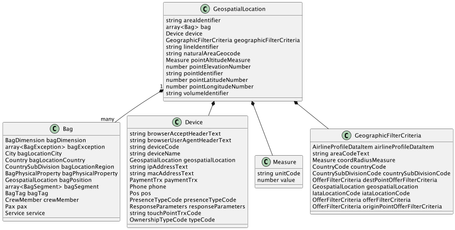
GeospatialLocation
A location with a spatial attribute, probably on the surface of the earth. For example: Longitude and Latitude
Properties
| Name |
Description |
Type |
Required |
Generic |
Enum |
Ignore |
| areaIdentifier |
The identifier of an area relevant to the business. Convention on identifier defined by the sender of the message. Potential example: 'PCA AB' for Passenger Check-in Area AB. |
string |
false |
|
|
false |
| bag |
A piece of luggage associated with a passenger, packed for traveling, and necessary or appropriate in connection with a journey. |
array |
false |
Bag |
--- |
false |
| device |
A Device upon which the secure transaction will occur. |
Device |
true |
|
|
false |
| geographicFilterCriteria |
A set of criteria used to filter results based on geographic preferences, including Area, State, City, Airport, or Geospatial information. |
GeographicFilterCriteria |
true |
|
|
false |
| lineIdentifier |
The identifier of a spatial line relevant to the business. Convention on identifier defined by the sender of the message. Potential example: 'PAP KRIC BNTLY CAVLR3 KIAD' for Planned Airway Path VOR name KRIC etc. |
string |
false |
|
|
false |
| naturalAreaGeocode |
Natural Area Geocode as defined by NAC Geographic Products Inc. Ex: 8KDB PGFD |
string |
false |
|
|
false |
| pointAltitudeMeasure |
The vertical distance of a level, a point or an object considered as a point, measured from mean sea level (MSL). |
Measure |
false |
|
|
false |
| pointElevationNumber |
The number of the spatial location point elevation. |
number |
false |
|
|
false |
| pointIdentifier |
The identifier of a point relevant to the business, to be located. Convention on identifier defined by the sender of the message. Potential example: 'BSP 123' for Bag Sortation Point 123. |
string |
false |
|
|
false |
| pointLatitudeNumber |
The number of the spatial location point latitude. |
number |
false |
|
|
false |
| pointLongitudeNumber |
The number of the spatial location point longitude. |
number |
false |
|
|
false |
| volumeIdentifier |
The identifier of a volume/space relevant to the business. Convention on identifier defined by the sender of the message. Potential example: 'ACS UPPER' for Upper Air Control Space. |
string |
false |
|
|
false |
{
  "areaIdentifier" : "string",
  "bag" : [ {
    "bagDimension" : { },
    "bagException" : [ { } ],
    "bagLocationCity" : { },
    "bagLocationCountry" : { },
    "bagLocationRegion" : { },
    "bagPhysicalProperty" : { },
    "bagPosition" : { },
    "bagSegment" : [ { } ],
    "bagTag" : { },
    "crewMember" : { },
    "pax" : { },
    "service" : { }
  } ],
  "device" : {
    "browserAcceptHeaderText" : "string",
    "browserUserAgentHeaderText" : "string",
    "deviceCode" : "string",
    "deviceName" : "string",
    "geospatialLocation" : { },
    "ipAddressText" : "string",
    "macAddressText" : "string",
    "paymentTrx" : { },
    "phone" : { },
    "pos" : { },
    "presenceTypeCode" : { },
    "responseParameters" : { },
    "touchPointTrxCode" : "string",
    "typeCode" : { }
  },
  "geographicFilterCriteria" : {
    "airlineProfileDataItem" : { },
    "areaCodeText" : "string",
    "coordRadiusMeasure" : { },
    "countryCode" : { },
    "countrySubDivisionCode" : { },
    "destPointOfferFilterCriteria" : { },
    "geospatialLocation" : { },
    "iataLocationCode" : { },
    "offerFilterCriteria" : { },
    "originPointOfferFilterCriteria" : { }
  },
  "lineIdentifier" : "string",
  "naturalAreaGeocode" : "string",
  "pointAltitudeMeasure" : {
    "unitCode" : "string",
    "value" : "number"
  },
  "pointElevationNumber" : "number",
  "pointIdentifier" : "string",
  "pointLatitudeNumber" : "number",
  "pointLongitudeNumber" : "number",
  "volumeIdentifier" : "string"
}
